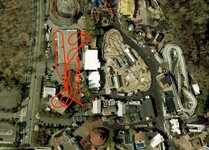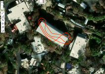
Register or Login to Hide This Ad for Free!
Darn. I got a pretty decent trace from the OpenStreetMap I could send over if nothin' else... let me try one more thing right quick.

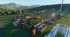
I did find good imagery but now it's not playing nice with my site, figuring it out rn

edit: Siren's Curse is up
edit 2: so is Circuit Breaker
edit 3: final addition for the night is my beloved Roar-o-Saurus. U can put it anywhere. I love u Roar-o-Saurus. One day i will clone u for my personal property
 
Last edited:
Soo question,
Are y'all tracing the coaster layout/track or are you including the width of footers etc?
I have been doing with the footers, as to see if things can actually fit where I want them.
🤷🏻‍♂️
 
Ah nice!
Yea I am the "let's see how specific and nerdy we can get with placement with this thing!" kind of guy.

AND ONCE AGAIN,
THANK YOU @northdetective !!!!!!!!!!
This things is great!!!!
I have been playing with it since the first hours of your posting!
If I am ever performing at a park you are visiting, the Dippin Dots will be on me!

btw, You don't need to know or care,
But for the past 10 years I have been building a theme park for my hometown (Memphis) on my computer.
I have been using an old a$$ Photoshop Elements, screen grabbing coasters and rides off google maps /marking up their length from there and trying to line it up on my map.
It has been annoying as heck, and you just made life soooo much easier.
 
as long as it's nowhere in Europe they should be fine lol. There's some weird sort of projection issue I'm trying to figure out which stretches shapes when they're close to the poles like seen below. trying to figure that out rn

You can put it into Grona Lund if you destroy half the rides and use the adjacent parking lot.

View attachment 43383
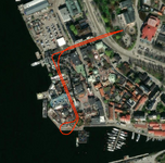
edit: fixed it

1789156436089.png
 
Last edited:
  • Wow
Reactions: Zachary
This may be a bit of an ask, but I got a request:
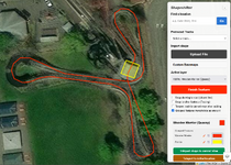
Is there any way on these we can get an identifiable feature to mark the station? Maybe an anchoring dot, a flag, a box, but anyway you can add in something to it @northdetective that can be the visual cue? Thanks!
 
This may be a bit of an ask, but I got a request:
Is there any way on these we can get an identifiable feature to mark the station? Maybe an anchoring dot, a flag, a box, but anyway you can add in something to it @northdetective that can be the visual cue? Thanks!

This is sorta something I've been thinking about too and also touches on what @Justlarry was talking about.

This may be way too complicated, but the ability to combine shapes would be killer. Would make tracing racing or dueling coaster layouts separately possible (vs the outline solution I used for the dueling Vekoma family boomerang). More importantly though, you could trace ride structure areas, station areas, and maintenance areas with polygons and then combine those polygons with the trace for the main track layout to make a much clearer visualization of a coaster in a new location.

This has come up specifically when I've used the tool for AF1 and for the Disko Coaster from SFDK too—both of those have areas of the layout designed specifically to run a path under. Trying to see where those portions are once you've teleported the layout elsewhere is pretty difficult. Some sort of ability to combine shapes would do wonders there too.

Know this is definitely major feature creep though so no worries if it's not feasible! Shapeshifter is already perfect in the like 95% of usecases I've encountered!
 
  • Like
Reactions: warfelg
This is sorta something I've been thinking about too and also touches on what @Justlarry was talking about.

This may be way too complicated, but the ability to combine shapes would be killer. Would make tracing racing or dueling coaster layouts separately possible (vs the outline solution I used for the dueling Vekoma family boomerang). More importantly though, you could trace ride structure areas, station areas, and maintenance areas with polygons and then combine those polygons with the trace for the main track layout to make a much clearer visualization of a coaster in a new location.

This has come up specifically when I've used the tool for AF1 and for the Disko Coaster from SFDK too—both of those have areas of the layout designed specifically to run a path under. Trying to see where those portions are once you've teleported the layout elsewhere is pretty difficult. Some sort of ability to combine shapes would do wonders there too.

Know this is definitely major feature creep though so no worries if it's not feasible! Shapeshifter is already perfect in the like 95% of usecases I've encountered!
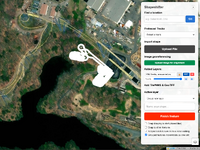
I brought it up because I know I've needed to keep google maps with the actual ride pulled up so I could ID the station. I've made myself two extra shapes for something I'm working on, and I'm including the path some just for points of reference. Additionally I think a few uses have used the tool well, but I think the station or something significant is put in a spot where it would be hard to access or be blocked by something else.
 
Okay group rotating should work now. There is a display bug with the vertices of the shapes while the rotating tool is active for groups, but when u click finish/move to another tool they should recalculate correctly. I have tried multiple times to fix the problem but it's just gonna be there for now

I don't plan to include anything like a legend or more drawing/display tools. The .geojson can be opened in QGIS or kml in google earth for more finished map products
 
Last edited:
1789342725486.png

Sorry for triple post

Update:

-Georeferencing support for images. U can upload an image, place it on the map, save as kmz which is probably the best export format for mapping w images rn or the evergreen geotiff

-Support for image import thru kmz (Amazonia from Bellewaerde at Great Adventure pictured)

-Custom basemap layer settings now export with .geojson (try loading Mack Blue Fire track and german orthophotos will load for the basemap)

-3-point rectangle tool: my favorite tool from Rhino

I guess one problem is right now that if u have raster data (images) they can't export in .geojson with ur vector data (shapes) so there's no one-file save state. but I'm okay w that because this is more of a tool for lightweight previzualization tweaks rather than a full fledged drawing platforn
 
Explain It Season 5 GIF by The Office
 
u can take a screenshot or drawing or whatever image and line it up with its real life location on the map for either tracing specific track plans or just putting pictures on the map. also u can make rectangles
 
  • Love
Reactions: Zachary
Consider Donating to Hide This Ad