Register or Login to Hide This Ad for Free!

northdetective

Crusader for a Greater Adventure
Silver Donor
Jan 18, 2026
908
2,504
210
hello all,

I updated the tool I made to theorize ArieForce One relocations so now users can draw their own shapes, drag/teleport them where intended, and either screenshot them or export the updated shape as a GeoJSON, GPX, or KML file (which u should be able to import to Google Earth on desktop for better/more varied imagery). Obviously this is not meant for any sort of task beyond quick thoosie mockups and it cannot be relied on for perfect accuracy, especially because the Esri World Imagery it uses for a basemap very clearly has warping in places/is not composed of perfect orthophotos. It's just for fun

northdetective.github.io/shapeshifter/

Here's how to use it:

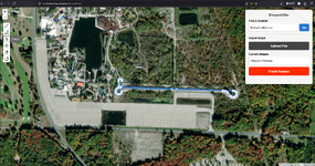
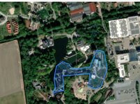
Screenshot 2026-06-27 125211.png

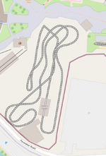
Search for what u wanna trace and then trace it. U can make polygons and polylines. I used Shivering Timbers because its layout is so simple in plan view. Click "Finish feature" when ur done


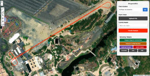
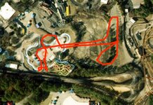
Screenshot 2026-06-27 125519.png

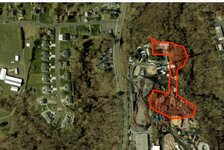
Then go to ur intended "destination" for size comparison and click the "Teleport shape to current view" button. Use the rotate and move buttons on the left as desired.

This brought to u by the fact that my college finally let my ArcGIS license expire more than two years after graduating

Also it's entirely vibecoded. Please do not expect me to be a passionate and reliable developer

Hope this is useful <3
 
Sooo... @northdetective... maybe some relocators are in order...? 😋

Yes. And just a thought @northdetective - I don’t know how easily it would be to do one of these but the other should be easy:
1 - Is there a way to combine all of these into one relocator where some coasters are already ‘pretraced’ and we can pick which one?
2 - Can we get a thread that has all of these in it? Constantly trying to find a post within a thread for the specific coasters locator is tougher than going through your profile to find the generic one. :)

Kthxbyeeeeeee.

My google gemini trial lasts about another week so yeah I can work on it. Will try to add color-coding and pretraced tracks and probably merge them all into shapeshifter. I will take some number of feature requests here and address them if possible

Reminder tho that as it stands, u can trace a shape urself using shapeshifter, download as geojson gpx or kmz, and then reupload for later use. I know it's not the best solution because usually the part that takes me the longest is just tracing the centerlines lol
 
everything is consolidated at northdetective.github.io/shapeshifter/

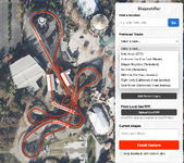
I'm currently tracing and adding rides from CGA but here's the pretraced list for now

1789060616547.png

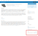
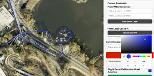
I added three preset basemaps (USGS Imagery w/labels, USGS imagery w/o labels, and openstreetmap) but there's also support for WMS servers or tile services using the ArcGIS REST API. This allowed me to trace the CGA rides using Santa Clara's orthoimagery. U can add ur own by going to the listing for a service on ArcGIS online and copying the URL from the bottom right (zoomed out for demonstration)

Screenshot 2026-09-10 130856.png

U can also add geotiffs. the site is based on leaflet which doesn't support geopdfs. sorry

Screenshot 2026-09-10 130321.png

And there's now a color picker. Lmk if there's anything broken or any specific qol features I missed (sorry @warfelg the logic for bending the geometry of AF1 is not something I'm gonna attempt)

edit: all CGA tracks have been added
 
Last edited:
Just for shits, might I suggest Circuit Breaker and Siren's Curse? Those are both off-the-shelf models that Vekoma offers, the "Pitfall" and the "Cliffhanger" respectively, and it might be something worth playing around with
 
Hey @northdetective - truly here, appreciate what you are doing with this ‘for the love of the game’. You could easily tell everyone to F-off an play with the basic shapeshifter you made but you are trying to better something that’s a joy to play with for random shenanigans like putting AF1 in the middle of my town (or how it fits oddly enough exactly over my high school).
 
I appreciate u appreciating it!! At this phase of the internet, it feels like simple tasks like dragging shapes are hidden behind layers and layers of obfuscated nonsense deep within tutorials about expensive professional software. Open and freely accessible data is my love language
 
I don't know what your workflow is, but would it help if instead of bugging you for new pre-traced options, the community provided traced layouts (via Shapeshifter) for you to add @northdetective? Like @shodowhater, I was imagining some standard clone options like the standard boomerang, SLC, family boomerang, etc but I'd also love to have Silver Comet and Superman: Ride of Steel in there too. Just hate to keep pinging you daily with every new coaster relocation option. 😋
 
Last edited:
oh that'd be great. I'm sure the list would quickly get to the point where the dropdown menu is inadequate but i'll deal w that

pretty much all I need for contributions is just to click the .geojson download button after tracing and send it to me with the park and coasters' names. very simple to add them from there even without AI

can we do attachments in dm here? that would work or I can set up a northdetective email if not
 
Tips for people tracing as to avoid flooding @northdetective with low quality traces: You want to follow the coaster's layout at ground level. Imagery is rarely taken from directly above so the higher points of a coaster will typically shift with altitude. Try to use footers with known vertical columns as guides. If you know a section of a coaster is straight, use that knowledge and draw it as such—use the lowest points of that straight section to best estimate the layout as it would be projected directly on the ground from above. Wooden coasters are extra hard to do well. Getting it right is more of an art than a science so make sure you have a good understanding of the layout in three dimensions before attempting to reproduce it in two.
 
Last edited:
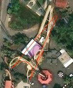
Double posting to provide a visual demonstration. Here's a Vekoma Boomerang I just traced and sent in to @northdetective:

Screenshot_20260910_182204_Chrome Beta.jpg

If you just traced the track in the imagery, it would have been super screwy. Gotta use the imagery to provide scale, but a lot of the time your lines aren't gonna visually overlap with the actual track you're seeing. Footers and station buildings are your friend.
 
the best i get using my stupid computer i really need to buy a new mouse and pcView attachment 44727View attachment 44728View attachment 44729

it's the thought that counts <3

Boomerang (thank u @Zachary), SLC, Niagara Silver Comet and SFA superman have been added

@shodowhater both vekoma tilts were built too recently for me to get good imagery to trace unfortunately, they're both under construction in their respective states' most recent orthoimages. Even in the esri imagery where siren's curse is finished, it was a very cloudy day at Cedar Point lol
 
Consider Donating to Hide This Ad