
RE: Project 2017
Multi-million dollar elevators confirmed.
Multi-million dollar elevators confirmed.

Pretzel Kaiser said:There are two buildings on the map. None of which are specified as anything. One of those could be the elevator.


Matthew said:Pretzel Kaiser said:There are two buildings on the map. None of which are specified as anything. One of those could be the elevator.
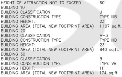
I understand, but none of the buildings planned are supposed to go over 23' in height, as you can see below. That doesn't seem to be a decent height for an elevator lift.

jonfin826 said:Is it possible that the elevator would show up in the ride plans as a ride element rather than in the site plans as a full blown building?


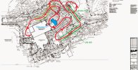
kingadam said:Pardon the terrible drawing (Paint isn't the best tool), but here is the track layout over top of the CC site plan if it helps anyone.

PrincessArlenasDad said:kingadam said:Pardon the terrible drawing (Paint isn't the best tool), but here is the track layout over top of the CC site plan if it helps anyone.
Is there a scale on this plan? Or does anyone know it? I can't find one on the page. I'd like to compare that to a map/birds eye view of the BGW site at the same scale.


kingadam said:PrincessArlenasDad said:kingadam said:Pardon the terrible drawing (Paint isn't the best tool), but here is the track layout over top of the CC site plan if it helps anyone.
Is there a scale on this plan? Or does anyone know it? I can't find one on the page. I'd like to compare that to a map/birds eye view of the BGW site at the same scale.
My best (educated) guess would be 60 scale. Printed it at 100% and used a scale to measure a known distance on the plans (measured on Google Maps first). Not very accurate considering I don't have a plotter and the image is blurry, but it will do.
PrincessArlenasDad said:kingadam said:PrincessArlenasDad said:kingadam said:Pardon the terrible drawing (Paint isn't the best tool), but here is the track layout over top of the CC site plan if it helps anyone.
Is there a scale on this plan? Or does anyone know it? I can't find one on the page. I'd like to compare that to a map/birds eye view of the BGW site at the same scale.
My best (educated) guess would be 60 scale. Printed it at 100% and used a scale to measure a known distance on the plans (measured on Google Maps first). Not very accurate considering I don't have a plotter and the image is blurry, but it will do.
Have you done the same for the BGW plans?

We use essential cookies to make this site work, and optional cookies to enhance your experience.