

hello all,
I updated the tool I made to theorize ArieForce One relocations so now users can draw their own shapes, drag/teleport them where intended, and either screenshot them or export the updated shape as a GeoJSON, GPX, or KML file (which u should be able to import to Google Earth on desktop for better/more varied imagery). Obviously this is not meant for any sort of task beyond quick thoosie mockups and it cannot be relied on for perfect accuracy, especially because the Esri World Imagery it uses for a basemap very clearly has warping in places/is not composed of perfect orthophotos. It's just for fun
northdetective.github.io/shapeshifter/
Here's how to use it:

Search for what u wanna trace and then trace it. U can make polygons and polylines. I used Shivering Timbers because its layout is so simple in plan view. Click "Finish feature" when ur done

Then go to ur intended "destination" for size comparison and click the "Teleport shape to current view" button. Use the rotate and move buttons on the left as desired.
This brought to u by the fact that my college finally let my ArcGIS license expire more than two years after graduating
Also it's entirely vibecoded. Please do not expect me to be a passionate and reliable developer
Hope this is useful <3
I updated the tool I made to theorize ArieForce One relocations so now users can draw their own shapes, drag/teleport them where intended, and either screenshot them or export the updated shape as a GeoJSON, GPX, or KML file (which u should be able to import to Google Earth on desktop for better/more varied imagery). Obviously this is not meant for any sort of task beyond quick thoosie mockups and it cannot be relied on for perfect accuracy, especially because the Esri World Imagery it uses for a basemap very clearly has warping in places/is not composed of perfect orthophotos. It's just for fun
northdetective.github.io/shapeshifter/
Here's how to use it:
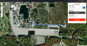
Search for what u wanna trace and then trace it. U can make polygons and polylines. I used Shivering Timbers because its layout is so simple in plan view. Click "Finish feature" when ur done
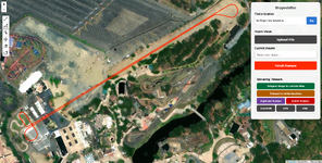
Then go to ur intended "destination" for size comparison and click the "Teleport shape to current view" button. Use the rotate and move buttons on the left as desired.
This brought to u by the fact that my college finally let my ArcGIS license expire more than two years after graduating
Also it's entirely vibecoded. Please do not expect me to be a passionate and reliable developer
Hope this is useful <3
