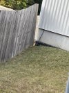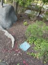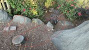
Paid a visit to KD today. Was able to spot a few survey markings around the former Volcano site. One directly next to the FOF building (pictured), one just inside the gate where the jeeps come out for Let's Get Wild (pictured) and just behind Reptilian (visible from the lift hill).

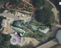
Also, on an unrelated note, there is land clearing taking place on the plot of land directly behind Grizzly. Not sure who owns this land. It was listed for sale sometime around 2014, however Hanover County's real estate assessment website doesn't show that a sale ever took place. Trees were cut down a few years ago, but now there's an excavator and dump truck on site (pictured). Likely has nothing to do with KD, but thought it was noteworthy.


Also, on an unrelated note, there is land clearing taking place on the plot of land directly behind Grizzly. Not sure who owns this land. It was listed for sale sometime around 2014, however Hanover County's real estate assessment website doesn't show that a sale ever took place. Trees were cut down a few years ago, but now there's an excavator and dump truck on site (pictured). Likely has nothing to do with KD, but thought it was noteworthy.

Last edited: