Register or Login to Hide This Ad for Free!
Nov 22, 2009
123
58
90
Iam not sure If this has been talked about here before.

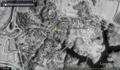
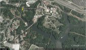
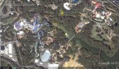
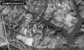
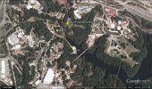
While checking out google earth of busch gardens williamsburg and having fun with the street view function. Found out that they have a historical imagery slide bar. images start with(newest)4/6/2010 and go back as far as 3/16/1989.
when running google earth just click on view and click on historical imagery then just slide the bar.

See how many differance you can find over the years other then the picture quality.
 
Google Earth has it's own thread in Everything Else, but I've never heard of that historical imagery slide bar before. Sounds like something I'd want to check out.:D
 
Well, I guess I'm going to bring this really old thread to life, instead of creating a new one. But I just wanted to mention the Google Earth overview of BGW and WCUSA has now been updated to April of 2014. Go check it out.
 
Are you using Google Maps or Google Earth, Applesauce? It looks like only Google Earth was updated- Google Maps satellite view still has the same view as it always has.
 
Ok, I downloaded Google Earth, and it worked. Nice to see Verbolten from above.
 
People mix Earth and Maps frequently. Honestly I thought the changes took place in Maps, but I just so happened to open Earth instead.
 
Earth has historic imagery that dates back to the 1980s. There's a clock button on the top dashboard labelled "Show Historic Imagery". Clicking it will open up a slider that you can drag back and forth between dates. Some are low quality but once you come across a few good pics its fascinating.

You can also do it over other amusement parks, major cities, tourist attractions etc. In some cases, images even date back to the 30s. Its amazing to see how things evolve in a few short years.
 
  • Like
Reactions: Nicole
Now Google Maps has been updated under overhead as well. The most drastic changes are in Banbury and Oktoberfest.
Street view is still the same, but if you want pictures from pre-Scott era then hurry up and take Google Street view images while it is the same.

Banbury:
Ks0OYPR.jpg

Oktoberfest:
udVVPx0.jpg

Shortly I may get images from before so that I can remember the park from beforehand.
 
The county's parcel view used to have satellite imagery dating beyond the park's construction. It's almost hard to think that the entire developed space the park uses used to be relatively flat woods.
 
  • Like
Reactions: CastleOSullivan
Consider Donating to Hide This Ad